THERE’S ONLY ONE WAY TO GO :
WATERSHED
The watershed of river
names are the oldest to appear on the map. Looking into them we find ourselves
gazing into the distorting mirror of time.
Water mothers the landscape. Our forebears
knew the name Dée as a Pictish goddess, Dewa, paired with the Don, Devona. A
similar pair runs to the Moray coast, Deveron and Findhorn, who names are dark
and fair variations of that which flows,
from a Proto Indo-European root. Jacob King suggests names such as these may
remain obscure because they were once taboo: being divine, not to be spoken.
The Dée
has been venerated since the time of the local Pictish tribe, the Càrnonacae,
and no doubt long before. There are rivers dedicated to the same dark goddess in Galloway, in Wales,
as Dee, in Spain as Deba and Deva, and in Ireland, as Abhainn Dé, or Dea,
which flows down from the Wicklow mountains to the sea at Arklow.
Many
hikers follow the river up the Làirig Ghru to its source, Fuaran Dhé, the
wells o’ Dee, on
the high plateau of Braeriach, the tawny highlands, or
brindled brae. In
comparison, very few have ever searched for the spring known as Maighdean
Mhonaidh, the
maiden of the hill, which rises high in Glen
Derry, the grove glen, near the
entrance to Coire an Fhir Bhoga, the
archer’s way corrie. In terms of fame the spring is an old cracked dish that is set aside for soap,
while the Fuaran Dhé
is filled with the romance of
altitude. ‘She’ has no name on the map; to find her my
friend Gill Russell had to peer among moor-grass and heather. She can acquire
namefulness through our currency. Why not find her
yourself?

Gill Russell and I have been collaborating on
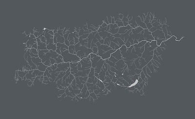
mapping the watersheds of Upper Deeside; her drawing of the entire river system
is included below. Gill’s first river maps can be found in her book, Lorg-Coise, Footprints, which we worked
on together, published by Deveron Arts.
Gill’s watershed drawing, ‘Eanich–Eidart–Dee’ shows the meeting of the sources of the Eanich/Eidart and the River Dee in bleak mountainous terrain at an elevation of 4000ft. It is a landscape that Gill refers to as 'otherwordly'; a reminder how rivers and burns that guided the earliest peoples into the icy hills. Quartz and flints buried in the soil tell of the first hunting band; they camped at the Chest of Dee, near the watershed with the Geldie, and left lithics by Caochanan Ruadha, Red Burnie, by the Feshie/Geldie watershed, in what is still challenging terrain today.
Pared of contours, woods, and names, the sequential circuitry of water reveals the region’s nervous system.
Watershed
water summit: watershed
the footprint of each
river is unique
a watershed is an
imperative: which way will you flow?
as a walker you become
aware: water defines land
burns fill with
weather; heavy rain releases their force
following a burn to its source relives the
formation of a glen
rivers make tracks through glens; paths follow
burns over hills
the track goes from A-B; the burn goes from S-B, to
N-U and R-
burns are criss-crossed, lochs are
star-crossed
burns are hemmed passages interspersed with
sounding pools
the name of a burn charges a walk with a sense of
mission: is there holly by Allt na Craoibhe-cuilinn?
rivers are syntax; hills
are grammar
Alec Finlay (after Gill Russell)
photography
River Dee, Inverchandlick: Hannah Devereux, 2016
River Dee following the Muckle Spate of 2015: Hannah Devereux, 2016
Maighdean Mhonaidh, Glen Derry: Hannah Devereux, 2015
images
River Dee, Inverchandlick: Hannah Devereux, 2016
River Dee following the Muckle Spate of 2015: Hannah Devereux, 2016
Maighdean Mhonaidh, Glen Derry: Hannah Devereux, 2015
images
Gill Russell:, Well-Well, Lorg-Coise, Footprints, 2014
Gill Russell: Eanich–Eidart–Dee, 2016
Gill Russell: Watershed (Ey), 2016
Gill Russell: Watershed (Gairn), 2016
Gill Russell: Watershed (Geldie), 2016
Gill Russell: Watershed (Upper Dee), 2016
Gill Russell: Eanich–Eidart–Dee, 2016
Gill Russell: Watershed (Ey), 2016
Gill Russell: Watershed (Gairn), 2016
Gill Russell: Watershed (Geldie), 2016
Gill Russell: Watershed (Upper Dee), 2016
Gathering was commissioned by Hauser & Wirth, for the
Fife Arms Hotel, Braemar; the project was launched in 2015 and will conclude in
2018.
The artist
residency at University of Aberdeen is funded by The Leverhulme Trust; the
project was launched in July 2016 and will conclude May 2017.


